The politics and political geography of Southern states can be just as interesting and distinctive as anywhere in the U.S. I have analyzed and mapped several recent elections in the South that show a different side of the region’s politics than the side that is commonly portrayed in the media.
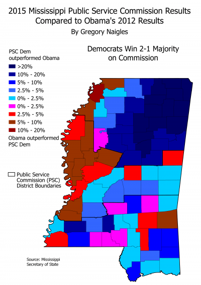
One map that I have made is this one, comparing the results of the 2015 Public Service Commission elections in Mississippi to those of the 2012 Presidential election.
Some maps of Southern states that I have made include:
- Alabama
- 2008 and 2012 Presidential results by precinct in Jefferson County (Birmingham), and comparisons between the two
- 2012 results by precinct for Chief Justice of the State Supreme Court in Jefferson County, and comparisons to presidential results
- Racial demographics by precinct in Jefferson County
- Florida
- 2008 and 2012 Presidential results by precinct in Miami-Dade County, and comparisons between the two
- Louisiana
- 2012 Presidential results by parish, House District, and precinct
- 2015 Gubernatorial results by parish, House District, and precinct, and comparisons to presidential results
- 2015 Lieutenant Governor results by parish, House District, and precinct
- Comparisons to 2012 presidential and 2015 gubernatorial results
- Mississippi
- 2011 and 2015 Public Service Commission (PSC) results, and comparisons between the two
- 2011 and 2015 turnout levels, and comparisons between the two
- Comparison between 2015 PSC results and 2012 presidential results
